The operational viability of Grand Canyon National Park rests upon a precarious, single-point-of-failure hydrological architecture. While the surface topography of the canyon draws millions of annual visitors, the biological ecosystems and human infrastructure within the park are entirely dependent on groundwater discharging from a hidden, highly complex subsurface network.
Recent three-dimensional mobile lidar mapping and quantitative dye-tracing experiments led by Northern Arizona University have exposed the fundamental mechanics of this system. The data demonstrates that the primary water supply for the entire park environment emerges from a single location: Roaring Springs, located on the canyon’s North Rim. This resource is fed through an accelerated karst conduit network that transports surface snowmelt across vast horizontal and vertical distances in fractions of the time predicted by standard matrix-flow porous aquifer models. Understanding the precise structural components, flow mechanics, and vulnerabilities of this subterranean system is critical for securing the long-term operational resilience of the park.
Structural Geomorphology and the Karst System Architecture
To understand the velocity and volume of the Grand Canyon’s water supply, the subsurface must be modeled not as a uniform, sponge-like aquifer, but as a dual-porosity hydrogeologic system. The primary regional aquifer is hosted within the lower Paleozoic carbonate section, specifically the Mississippian Redwall Limestone and the underlying Cambrian Muav Limestone of the Tonto Group. This structural block is capped by less permeable sedimentary layers, yet it remains vertically connected to the surface via an extensive network of faults, fractures, and solution-widened sinkholes across the high-elevation Kaibab Plateau.
The physical architecture of this regional system is fundamentally shaped by karstification—the chemical dissolution of carbonate rocks by weak carbonic acid inherent in infiltrating rainwater and snowmelt. Over geological time, this process has engineered an underground layout analogized to a fractured network of interconnected pipes and open chambers.
- The Matrix Component: Comprises the unfractured, solid rock block. It features high storage capacity but exceptionally low hydraulic conductivity, meaning water moves through the microscopic pores of the stone at an incremental pace.
- The Conduit Component: Comprises the solution-widened fractures, bedding planes, and caves mapped by the research team. This component features low storage volume but exceptionally high hydraulic conductivity, functioning as a subterranean highway system for fluids.
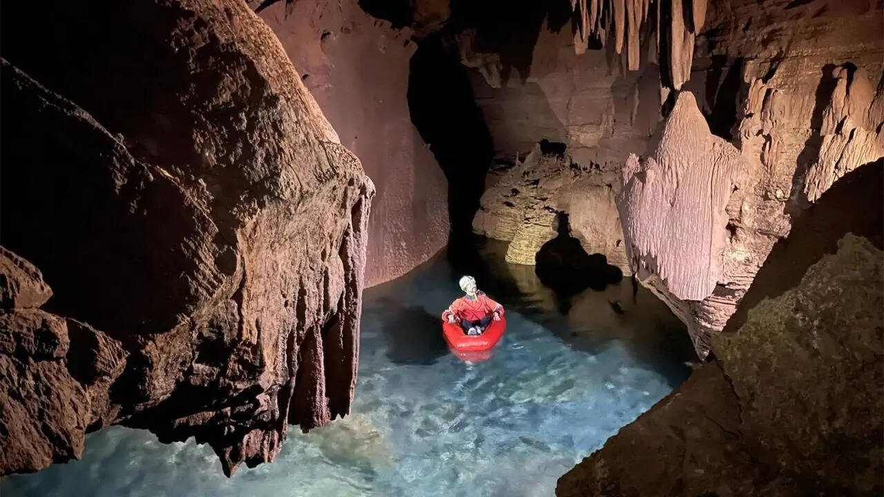
Data acquired through 45 days of underground mapping using mobile lidar scanners documented over 10 kilometers of previously unmapped, high-resolution cave corridors. These spatial models reveal that the structural geometry of the caves follows prominent structural faults and joints. This confirms that tectonic fracturing dictates the path of chemical dissolution, creating direct, low-resistance pathways that cut through thousands of vertical feet of stratigraphy.
Hydrodynamics and Transport Velocity Metrics
The defining feature of the Grand Canyon's karst network is the extreme velocity at which water moves through the subsurface. In standard sandstone aquifers, groundwater migration is measured in centimeters or meters per year. In the Kaibab-Redwall karst system, the transport velocity scales by multiple orders of magnitude.
Quantitative dye-tracing experiments conducted across the Kaibab Plateau reveal the operational parameters of this system. When fluorescent tracers were injected into surface sinkholes on the plateau, the dye traveled approximately 20 kilometers laterally and thousands of feet vertically, emerging at Roaring Springs in as little as seven days.
This implies a linear transport velocity exceeding 2.8 kilometers per day. Such accelerated transmission rates are only physically achievable through open, un-occluded conduit flow where fluid dynamics transition from laminar matrix flow to turbulent pipe flow.
The primary driver of this system is the seasonal accumulation and subsequent melting of snow on the Kaibab Plateau. The plateau acts as a massive high-elevation collection basin. As temperatures rise in spring, the resulting snowmelt introduces a high-volume hydraulic pulse into the sinkholes. This input creates a cascading hydraulic head pressure that rapidly displaces older, stored groundwater in the lower karst chambers, forcing a high-volume discharge at the spring face.
The Transcanyon Infrastructure and Engineering Bottlenecks
The critical nature of this hydrological system is underscored by the physical infrastructure built to exploit it. Roaring Springs discharges a highly consistent baseflow, averaging approximately 21 cubic feet per second. Because the Colorado River flowing at the bottom of the canyon is highly silted and requires extensive chemical treatment, the National Park Service relies entirely on gravity-fed capture at Roaring Springs to supply drinking water to both the North and South Rims.
The mechanics of the distribution system follow a demanding engineering logic:
- Capture: Water is intercepted directly at the cave mouth of Roaring Springs on the North Rim, entirely bypassing surface contaminants.
- Gravity Descent: The water flows down a 12.5-mile section of the Transcanyon Pipeline (TCP), descending 3,800 vertical feet to the floor of the canyon at Bright Angel Creek.
- North Rim Lift: A portion of the water is mechanically pumped 3,000 vertical feet upward from the spring to supply the North Rim facilities.
- South Rim Lift: The remaining volume crosses the canyon floor via the TCP and is mechanically pressurized at a pumping station, lifting it 7,000 vertical feet to the South Rim Village.
This infrastructure is exceptionally vulnerable to mechanical and geological disruptions. The TCP was constructed mid-century and suffers frequent catastrophic breaks due to flash floods, rockfalls, and internal pressure surges. Because there is zero modular redundancy in the primary water source, any failure at the Roaring Springs intake or along the main line completely halts water delivery to the South Rim, which hosts the vast majority of the park's multi-million visitor population.
Contamination Vector Analysis and Systemic Risks
The same structural features that permit clean, rapid water transit from the plateau to the canyon floor introduce severe systemic vulnerabilities. In traditional sand or gravel aquifers, slow filtration through pore spaces filters out particulate matter, pathogens, and chemical compounds. The "Swiss cheese" architecture of the Redwall-Muav karst system lacks this filtration capability.
The primary risks to the water supply are categorized into three distinct operational vectors:
The Wildfire-Erosion Loop
High-severity wildfires on the Kaibab Plateau destroy surface vegetation and alter soil chemistry, creating hydrophobic soil layers. When rain falls on these burn scars, surface runoff increases exponentially. This runoff carries high concentrations of ash, heavy metals, and dissolved organic carbon directly into the sinkholes. Because the conduit network offers no mechanical filtration, these contaminants can arrive at the Roaring Springs intake within a week, overwhelming standard chlorination systems and forcing an operational shutdown of the pipeline.
Pathogenic Infiltration
Surface activities on the plateau, including wildlife migration, livestock grazing, and human recreation, introduce biological pathogens like E. coli and Giardia into surface depressions. During intense precipitation events, these bacteria are swept directly into the conduit stream. The rapid transit time ensures that pathogens survive the journey without undergoing natural die-off processes that occur over longer subterranean residence times.
Anthropogenic Drawdown and Structural Contamination
Outside park boundaries, regional municipal expansion and industrial developments tap into the broader Coconino and Redwall-Muav aquifers. Accelerated groundwater pumping from deep wells reduces the overall hydraulic head of the regional system. This drawdown risks altering the internal flow paths within the karst chambers, potentially pulling lower-quality, highly mineralized water from deeper, stagnant zones into the active conduit streams feeding Roaring Springs.
Resource Management Framework
To mitigate these risks and ensure the continuity of park operations, water resource managers cannot rely on reactive water treatment protocols. They must deploy a predictive, basin-wide management framework.
The first step requires integrating the newly acquired 3D cave models with airborne lidar and satellite remote sensing data to precisely map every active sinkhole and recharge zone across the Kaibab Plateau. This spatial ledger must be paired with automated, real-time water quality sensors installed inside the Roaring Springs cave system to measure turbidity, electrical conductivity, and temperature fluctuations at hourly intervals.
Because changes in turbidity and conductivity serve as immediate precursors to contaminant arrival, these sensors function as an early warning system. For example, a sudden drop in water temperature paired with a spike in turbidity indicates that fresh, unfiltered surface runoff has entered the main conduit system.
By mapping the correlation between specific sinkhole inputs and spring discharge characteristics, park operations can predict the exact arrival window of a contamination plume. This predictive window allows managers to proactively isolate storage tanks, divert contaminated baseline flows away from the Transcanyon Pipeline, and prevent system-wide contamination before the first liter of degraded water enters the municipal delivery network.